A natural zone is a large territory with similar climate, soils, vegetation, and animal life. Zones are not scattered randomly: they systematically replace each other from the poles to the equator because the ratio of heat and moisture changes in this direction. We will examine all the Earth's natural zones in order, compile them into a single table with climate, soils, plants, and animals, go through Russia's zones from north to south, and learn to distinguish latitudinal zonation from altitudinal zonation. At the end, there's an interactive trainer.
What is a natural zone
A natural zone is a large natural complex with a uniform climate, soils, vegetation, and animal life. Zones are mainly elongated from west to east in wide bands and replace each other as you move towards the equator.
The reason is simple: the closer to the equator, the more solar heat the surface receives. A second factor is added to heat – moisture. It is the ratio of heat and moisture that determines what will grow in a particular place: with high heat and abundant moisture, an equatorial forest; with the same heat but no rain, a desert.
Then the chain reaction works. Climate determines the soil-forming processes, and climate and soils together determine which plants will take root, and vegetation dictates what can be eaten and where to hide in that zone.
Earth's Natural Zones from North to South: Latitudinal Zonation
The regular change of natural zones from the poles to the equator is called latitudinal zonation. You need to know the order of zones by heart – half of the assignments on the topic are based on it.
Pay attention to two things. Firstly, each zone corresponds to its climatic zone: tundra to subarctic, taiga and steppes to temperate, savannas to subequatorial, and humid forests to equatorial. Secondly, there are several zones in the temperate belt: taiga, mixed and deciduous forests, forest-steppes and steppes, semi-deserts and deserts. They replace each other not only from north to south but also deeper into the continent – where there is less and less moisture.
Natural Zones Table: Climate, Soils, Plants, and Animals
Below is a table of natural zones. Read it from top to bottom: this represents movement from the pole to the equator. To help you remember, keep in mind the key feature of each zone: tundra – permafrost, taiga – podzolic soils and coniferous trees, steppe – chernozem and grasses, savanna – dry and wet seasons, equatorial forest – multi-layered structure.
| Natural Zone | Climate, Soils, Plants, Animals |
|---|---|
| Arctic Desertsarctic zone | Location Greenland, islands of the Arctic Ocean, Antarctica Climate very cold year-round, short summers, little precipitation Soils arctic, thin, much rock and ice Plants mosses, lichens, algae on rocks Animals polar bear, seal, seabird colonies |
| Tundrasubarctic zone | Location northern Eurasia and North America, Alaska, Chukotka Climate long winters, cool summers, permafrost Soils tundra-gley, waterlogged Plants reindeer moss, dwarf birch, polar willow Animals reindeer, arctic fox, snowy owl, ptarmigan |
| Taigatemperate zone | Location Siberia, Canada, Scandinavia Climate frosty winters, warm short summers, 300–600 mm precipitation Soils podzolic, acidic, and poor Plants spruce, pine, fir, larch, Siberian pine Animals elk, brown bear, lynx, capercaillie |
| Mixed and Deciduous Foreststemperate zone | Location East European Plain, Western Europe, Eastern USA Climate milder winters, warm summers, 500–1000 mm precipitation Soils sod-podzolic, gray and brown forest soils Plants oak, linden, maple, ash, birch, spruce Animals wild boar, roe deer, fox, squirrel, marten |
| Forest-Steppes and Steppestemperate zone | Location southern East European Plain, American prairies, Argentine pampas Climate hot dry summers, 250–500 mm precipitation, trees lack moisture Soils chernozem and chestnut – most fertile Plants feather grass, fescue, bentgrass, various herbs Animals ground squirrel, marmot, steppe eagle, bustard |
| Temperate Deserts and Semi-Desertstemperate zone | Location Gobi, Karakum, Caspian Depression Climate hot dry summers and frosty winters, less than 250 mm precipitation Soils brown and gray-brown, often saline Plants wormwood, saltworts, saxaul, camel's thorn Animals jerboa, gerbil, goitered gazelle, lizards |
| Sclerophyllous Forests and Shrubssubtropical zone | Location Mediterranean, California, southern Australia Climate dry hot summers and warm humid winters Soils brown soils Plants cork oak, olive, laurel, myrtle, maquis Animals mouflon, jackal, turtles, lizards |
| Tropical Desertstropical zone | Location Sahara, Arabian Desert, Atacama, Namib Climate driest and hottest climate, rare rains, cold nights Soils desert soils, often sand and gravel Plants succulents, cacti of America, ephemerals Animals camel, fennec fox, addax antelope, scorpions |
| Savannas and Sparse Woodlandssubequatorial zone | Location Africa south of the Sahara, Brazilian Highlands, northern Australia Climate hot all year round, dry and wet seasons alternate Soils red-brown and red ferralitic Plants tall grasses, baobab, umbrella acacia Animals zebra, wildebeest, elephant, giraffe, lion |
| Humid Equatorial Forestsequatorial zone | Location Amazonia, Congo Basin, Southeast Asia Climate hot and humid year-round, over 2000 mm precipitation Soils red-yellow ferralitic, poor in nutrients Plants multi-layered forest, lianas, epiphytes, ficus trees Animals monkeys, sloth, jaguar, parrots and toucans |
Natural Zones of Russia
Russia stretches almost 4,000 kilometers from north to south, so latitudinal zonation is clearly visible on its map: the country encompasses eight natural zones.
The largest of them is the taiga: school textbooks estimate its share at about 60% of the country's area. The most fertile is the steppe and forest-steppe with chernozem soils; this is why it is almost entirely cultivated, and remnants of true steppe are preserved mainly in nature reserves. And the harshest is the arctic desert on the islands of the Arctic Ocean.
An important feature: zones in Russia expand and contract. On the East European Plain, deciduous forests extend far to the east, while beyond the Urals they almost disappear – the climate becomes more continental and drier.
Latitudinal Zonation and Altitudinal Zonation: What's the Difference
These two concepts are constantly confused, although they are easy to distinguish.
Latitudinal zonation is the change of natural zones on plains as you move towards the equator, i.e., by latitude. The reason is the different amount of solar heat.
Altitudinal zonation is the change of natural complexes as you ascend mountains. The reason is different: temperature and atmospheric pressure decrease with altitude, and precipitation increases up to a certain height.
The belts in the mountains follow the same order as the zones from the equator to the pole, but they are not the same thing. A mountain "starts" with the zone it is located in: in the Caucasus, there are forests at the bottom, while in the Polar Urals, there is mountain tundra immediately. And the higher the mountain and the closer it is to the equator, the more belts there are on its slopes.
Why Zones Don't Form Straight Bands
The map shows that natural zones never form perfect bands along parallels. The boundaries are blurred by several factors:
- Oceans and ocean currents. Warm currents bring moisture and push forests northward, while cold currents create deserts right on the coast – this is how the Atacama and Namib formed.
- Mountains. They intercept moist winds: forests on the windward side, dry steppes and deserts on the leeward side.
- Distance from the ocean. Less moisture reaches the interior of the continent, so forests are replaced by forest-steppes, steppes, and semi-deserts not from north to south, but from west to east.
Therefore, zones are often described not as bands, but as patches and tongues, and the boundaries between them are considered gradual: there are always transitional zones between zones, such as forest-tundra or forest-steppe.
How Humans Have Changed Natural Zones and How They Are Protected
Almost all natural zones have been altered by human activity, and the most convenient ones for life have been affected the most.
- Steppes and forest-steppes have been plowed. Chernozem soils are too fertile to leave them under grass: true virgin steppe is preserved only in isolated areas, mainly in nature reserves.
- Forests are being logged. In the temperate zone, forests have been cleared for centuries for arable land and cities, and deforestation is currently fastest in the humid equatorial forests – along with the forests, species that live nowhere else disappear.
- Dry zones are advancing. Due to overgrazing, cultivation of light soils, and excessive irrigation, semi-deserts are turning into deserts. This process is called desertification, and it is most active on the southern edge of the Sahara.
To preserve untouched natural areas, specially protected natural areas are created. In a nature reserve, any economic activity is prohibited; only scientists are allowed access. In a national park, nature is also protected, but regulated tourism is permitted. In a sanctuary, only certain activities are restricted – for example, hunting. Rare plant and animal species are listed in the Red Book, and it is forbidden to hunt or collect them.
Examples: How to Identify a Natural Zone
Example 1. Identifying a Zone by Description
Task. "The winter lasts about eight months, the summer is short and cool. The soil thaws only a few tens of centimeters deep; below that is permafrost. There are no trees, but there are mosses, lichens, and creeping shrubs." Name the natural zone and its soils.
Step 1. Look at the temperature. Eight months of winter and a cool summer indicate the subarctic zone, north of the forest zone.
Step 2. Find the key feature. Permafrost close to the surface is a sure sign of tundra and arctic desert.
Step 3. Differentiate between the two options by vegetation. In the arctic desert, vegetation is sparse, consisting of isolated patches of mosses and lichens on rocks. Here, the cover is continuous, and there are shrubs – therefore, it is tundra.
Step 4. Add the soils. Permafrost prevents water from draining downwards, so the soil is waterlogged – this forms tundra-gley soils.
Answer: Tundra, tundra-gley soils.
Example 2. Identifying a Zone by Coordinates
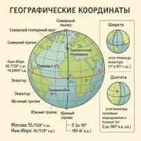
Task. Which natural zone is located at the coordinates 2° S latitude, 22° E longitude?
Step 1. Read the hemispheres. Southern latitude and eastern longitude mean the Southern and Eastern Hemispheres.
Step 2. Locate the continent. 22° E longitude at about zero latitude is the center of Africa, the Congo Basin.
Step 3. Determine the climatic zone. 2° is practically the equator, meaning the equatorial zone: hot and very humid year-round.
Step 4. Name the zone. The humid equatorial forests correspond to the equatorial zone.
Answer: Humid equatorial forests.
Check yourself at the second point: 25° N latitude, 25° E longitude. This is northern Africa, the tropical zone, the Sahara – tropical desert.
Example 3. Arranging Russia's Natural Zones from North to South
Task. Arrange in order from north to south: steppe, tundra, taiga, arctic deserts, mixed forests.
Step 1. Find the extreme points. The northernmost are the arctic deserts (islands of the Arctic Ocean). The southernmost in this list is the steppe.
Step 2. Proceed by increasing warmth. After the arctic deserts, it gets warmer: a continuous vegetation cover appears, but there are still no trees – tundra.
Step 3. Place the forest zones. As soon as the summer warms enough for trees, the taiga begins, and further south, where winters are milder, mixed forests.
Step 4. Conclude with the steppe. Further south, there is enough warmth, but not enough moisture – the forest recedes, leaving grasses.
Answer: Arctic deserts → Tundra → Taiga → Mixed Forests → Steppe.
Example 4. Zonation or Belt System?
Task. Determine what is described in each case.
a) A traveler drives a car from Arkhangelsk to Rostov-on-Don and observes the taiga giving way to mixed forests, then forest-steppe, and finally steppe.
Analysis. The movement is across a plain from north to south, latitude changes – this is latitudinal zonation.
b) An alpinist climbs the slope of Mount Elbrus and passes through beech forest, subalpine meadows, rocky scree, and glaciers.
Analysis. The complexes change with altitude, the latitude remains the same – this is altitudinal zonation.
General tip. Ask yourself: did the latitude or the altitude change? Traveling on a map means zonation, climbing a mountain means belt system.
Common Mistakes
-
Confusing terms: saying "altitudinal zonation" and "latitudinal belt system".
The terms are fixed: on plains by latitude – latitudinal zonation, in mountains by altitude – altitudinal zonation. Remember the connection: zone – plain, belt – mountain.
-
Thinking that the soils of humid equatorial forests are the richest: if there is a lot of vegetation, then the soil is fertile.
On the contrary. Red-yellow ferralitic soils are poor in nutrients: almost all organic matter is locked within the plants themselves, and abundant rainfall quickly washes away the rest. Therefore, logged equatorial forest yields crops for only 2–3 years. The most fertile soils are the chernozems of the steppes.
-
Placing chernozems in the taiga and podzolic soils in the steppe.
It all depends on where the water moves. In the taiga, precipitation exceeds evaporation, water leaches the soil and carries nutrients downwards – resulting in acidic podzolic soils. In the steppe, evaporation exceeds precipitation, nutrients remain at the top, and dense grass cover adds humus each year – thus, chernozem accumulates.
-
Assuming that a desert is always hot and sandy.
A desert is defined not by temperature, but by an extreme lack of moisture and life. Therefore, arctic deserts are also deserts, just cold ones. And among hot deserts, sandy ones make up a smaller portion: stony and clay deserts are more common.
-
Expecting zones to form straight bands strictly along parallels.
Bands are broken by oceans, currents, mountains, and distance from the sea. Due to cold currents, deserts appear right on the coast (Atacama, Namib), and in the interior of Eurasia, forests are replaced by steppes from west to east, not north to south.
-
Drawing a clear line between zones, like a border between countries.
The transition is always gradual, and it usually has its own name: between the tundra and taiga lies the forest-tundra, between the forest and steppe – the forest-steppe, between the steppe and desert – the semi-desert. This is why the number of "main" zones differs in various textbooks.
Questions and Answers
What is a natural zone in simple terms?
A natural zone is a large part of the land where the climate, soils, plants, and animals form a single stable complex. In simpler terms, it's a territory with uniform nature: tundra is everywhere similar to tundra, and savanna is like savanna, wherever they are located.
How many natural zones are there in the world?
There is no single number: it all depends on how detailed the division of transitional zones is. In school curricula, usually 8 to 10 main zones are identified – from arctic deserts to humid equatorial forests. If forest-tundra, forest-steppe, and semi-deserts are counted separately, there will be more zones.
In what order do natural zones go from north to south?
Arctic deserts, tundra and forest-tundra, taiga, mixed and deciduous forests, forest-steppes and steppes, temperate deserts and semi-deserts, subtropical sclerophyllous forests, tropical deserts, savannas and sparse woodlands, humid equatorial forests. South of the equator, the same sequence repeats in reverse order.
Which natural zone is the largest in Russia?
Taiga. School textbooks estimate its share at about 60% of the country's area: it stretches in a continuous band from Karelia to the Pacific coast. Tundra is the second largest in area.
How does latitudinal zonation differ from altitudinal zonation?
Latitudinal zonation is the change of natural zones on plains when moving from the poles to the equator, caused by the different amount of solar heat. Altitudinal zonation is the change of complexes when ascending mountains, caused by decreasing temperature with altitude. The order of belts is similar to the order of zones, but it begins with the zone in which the mountain is located.
In which natural zone are the most fertile soils found?
In the steppes and forest-steppes of the temperate zone – this is where chernozems form. Dense grass cover dies off annually and accumulates humus, and evaporation prevents rain from washing nutrients deep into the soil. Therefore, steppes are almost universally cultivated.
What soils are characteristic of each natural zone?
In brief: arctic deserts – arctic soils, tundra – tundra-gley soils, taiga – podzolic soils, mixed and deciduous forests – sod-podzolic and gray forest soils, steppes – chernozem and chestnut soils, temperate deserts – brown and gray-brown soils, savannas – red-brown soils, humid equatorial forests – red-yellow ferralitic soils.